Diagnosis and preliminary studies
• Understand the changes of the urban systems
• Through a system of human, spatial, economical, governance, technology interacting factors.
• Highlight weak signals and opinion levers of change, transition, breakthrough;
• Lead research and survey in an holistic way.
• Characterize large geographical and metropolitan regions
• Through the glance of individuals positive energy, communities collective intelligence, people self-confidence, the trust in improvement and future.
• Enhance common and specific features
• About the worldwide urban growth, the levers, the urban patterns, the expansion mechanisms.
• Identify « standard » development schemes and understand the lifestyle within the cities of tomorrow
Deep appraisal and preparation of road maps
• Locate links between local and global levels
• Highlight the impact of social, economy, productive, governance local networks on the city next step generation
• Grasp urban on going and under-construction urban ecosystems
• Eco-districts, smartcities, slums, favelas, kampungs, villages, integrated townships, special economic zones, organizing vehicle-infrastructure-service solutions.
• Identify the interactions between specific clusters and the generated trip patterns
• Ex. Islanding mobility schemes generated by archipelagoes clusters
Assessment and implementation of relevant good practices
• Inspiration from low tech solutions to push innovation
• Focus on frugal innovation enhancing local know-how and using local resources.
• Jugaad, jeitinho, systèmeD, reverse use, upgrade of one major essential function, deprive of secondary fits.
• Observe and build upon cross breedings
• Between developing countries : cooperation, exchange of best practices
• Crossing between top down schemes and grass-root know-how
• Enhance significant trends of change
• Ex. tryptic energy/connectivity/ mobility
• Energy independancy, air quality concerns, need of disseminated and cloud mobility
Launch and expertise support on projects
• Example of three main achievements
• Clean Air Initiative for Rio de Janeiro: support for pollution dispersion modeling based on mobile sources and dwelling typology emission within a square of 60 km2.
• Setting up of two round tables of experts, meeting of stakeholders, field visits, about the mobility issues in Jakarta and Indonesia.
• Participation to the international professional workshop of urban design in Naya Raipur,

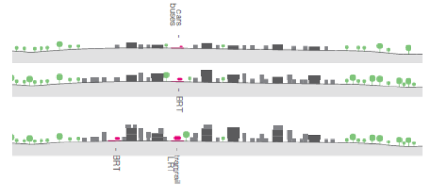
Massify public transport corridors
• Connect densely populated areas with high density work places
• Optimize the existing metro lines extension and layout, strengthen the network effect
• Ensure and maximize intermodality between diverse modes of transport
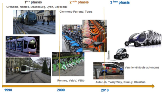
• Phase the modes of transport progressive evolution and successive steps of implementation over time: Bus, BRT, Tramway, Metro, LRT, MRT in accordance with the urban densification
• Determine priority corridors within an overall accessibility pattern according to the different city scales : metropolitan region, urban area, municipalities, neighbourhoods
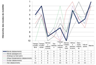
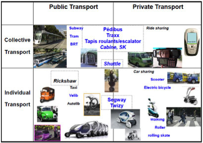
Classify and rank the whole modal chain means operationalizing the complementarity between motorized, non-motorized transport, public, private, collective, individual means.
• Make a coherent whole of densities, speeds, urban functions (dwelling, employment, commercial)
• Render clear, intelligible and obvious the modes hierarchy and their interrelated benefit (feeder/ dispatcher) in order to increase their effectiveness and limit their competition
• Provide the various travel means with binder, flexibility, temporization through infrastructure management, parking organization, interconnection of fast/slow flows schemes adapted systems, in order to alleviate breaking bulks and itinerary cut-out.
• Foster the combination of diverse trip purposes
Spread, shift, and allocate the flows over time and distribute them in the urban space.
• The right mode at the right place at the right moment for the right travel distance
• Embed peak hour and off-peak period rhythms, anticipate struggling and incompatible needs by pooling solutions as early as possible: taxi sharing, fleets of self-service vehicles, …
• Work on infrastructure management : reversible lanes, adaptative speed, variable parking provision and pricing, …
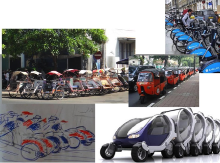
• Integrate interstitial and intermediary mobility within preliminary studies and planning frameworks (off public transport and private car): rickshaws, moto-taxis, bikes, quadricycles,…

Enhance and develop the mobility of proximity
• Facilitate the conditions required for modal shift from heavy modes of transport towards walking, non-motorized and electric two-wheelers according to the distance travelled to allow the load mitigation of public transport lines
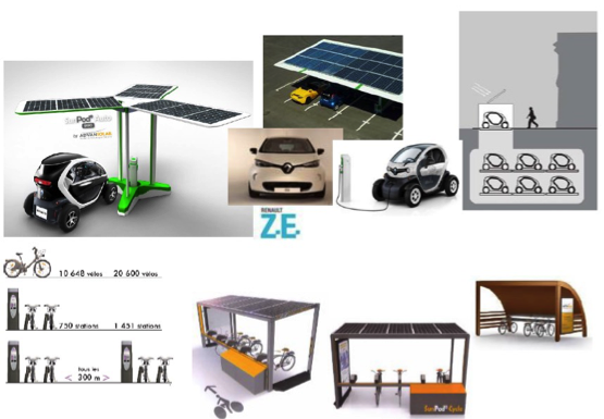
Expand local zero emission mobility solutions
• Promote ecosystem structures of off microgrids supplying renewable energy for local consumption needs
• Design and build multiple polarities in city as micro-hubs providing energy, connectivity and services: EV recharging ports, EV taxi stations, municipal information & cyber kiosks, …

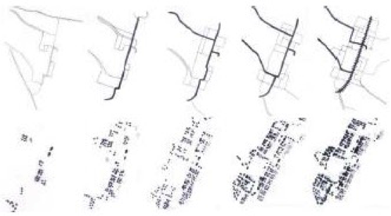
Create ways of interacting between urban development schemes and the transportation networks
• Assess the impact and the synergy of urban expansions related to each scale: the metropolitan region, the urban area, the districts, the neighbourhoods
• Take the landscape opportunities (topography, tree-planting , important views…) to implement new urban development that includes major infrastructures
Connect and incorporate urban projects to the mobility networks
• Coordinate the building development stages based on suitable and gradual catchment of public transport servicing in which alternatives to the car are part of the system
• Pave the way for finding functional and spatial links between global archipelago clusters and the other parts of the city
• Avoid accessibility deficit due to cut-off effects or physical distance
• Set-up approach pathways inducing spontaneous speed decrease from expressways towards residential areas

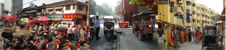
Make landlocks and enclaved areas accessible
• Facing stringent access condition areas with high populated density and smaller track width (lanes, soi, hutongs, gang, …) encourage the integration of traditional and artisanal forms of transport, on-demand transport, paratransit, based of community and neighbourhood behaviour. This ensures a spatial and temporal continuous coverage
• Allocate alternative means of transport to cadent service feeding heavy infrastructure modes
Provide an identity to intermodal hubs, give an appropriate function to functional premises
• Create multiple polarities within the diverse scales and magnitude of built-up areas in order to articulate the fluxes functionally. The aim is to ease changing from on mode to another supported by waypoint elements providing identity to the areas and offering multifunctional services: self-service bikes, Ev recharging pods, innovative parking lot facilities, pedestrian sit-back and break areas, left urban delivery lockers, street vendors accommodation, …
Cross bottom-up and grassroot innovative initiatives with top-down development schemes to reach operational dissemination level
• Harmonize and coordinate the initiatives developed at different levels with significant cross-breeding. Find the intermediate operational level for operational incremental dissemination with the whole actor contribution

Anticipate changes and breakthroughs, identify weak signals
Use transport infrastructure as basis and support to design integrated and structured urban space
Organize a distributed intelligence network of the transportation means
Use & adapt identified best practices according to the context, make service and technological innovations resonate with local solution
Use transport infrastructure as basis and support to design integrated and structured urban space
• Consider transportation networks as a support for urban design projects (public space, urban furniture, lightning, landscape,…) and not restrictively as a technical equipment
Organize a distributed intelligence network of the transportation means
• Build comprehensive offerings based on the energy-connectivity couple using local resources ( gas, wind, solar, biomass, hydro,…) for local needs
Use & adapt identified best practices according to the context, make service and technological innovations resonate with local solution
• Enhance and develop frugal solutions with energy consumption and occupation of public areas saving targets ; emphasize sharing means and pooling resources
• Inspire innovative solution and business model framework from effective implemented best practices and existing know-how
• The key issue is to find innovative management of existing solutions; most of them do already operate in the informal sector or within specific community eco-systems

GREBERT Jean
Born 09 th June 1960, French citizenship, married, 4 children
Adress : 8, rue du Commandant René Mouchotte, 75014 PARIS, France
Tél. +33 (0)6 74 00 21 20
E-mail : contact@catchcityvision.com
IN BRIEF
Expert in designing, appraising, piloting & monitoring urban systems projects
CATCH
CITY VISION
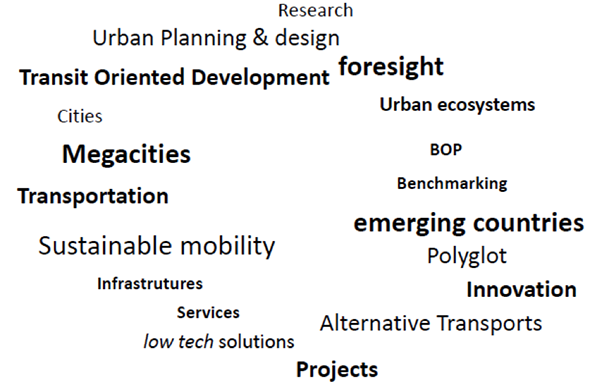
TOPICS TAG
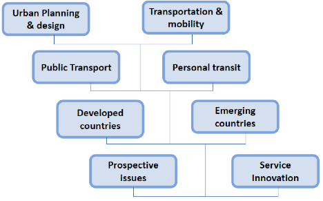
- Expertise in planning and urban development, renewal projects comprising mobility patterns issues.
- Prospective studies and research in the field of urban systems interacting with transportation concern.
- Analysis, benchmarking and feasibility appraisal of innovation in urban project, public transport offer, personal mobility, para-transit, based on emerging countries cases.
- Develop a comprehensive understanding of the city global context, a urban system situational awareness of a metropolitan region: lines of force, imbalances, potential;
- Identify structuring interactions between transportation and urban development : areas of pressure and stakes, interconnection, sensitive locations of premises and amenities, maximization of the territories, infrastructure restructuring and renewal.
- Take into account the whole modal chain enhancing complementarity between modes : public transport, private motorization, alternative means, para transit.
- Set up a cross comparison focusing on convergences and specificities through a worldwide approach fast growing and new emerging countries oriented.
- Capture weak signals and grasp Low Tech innovations.
- Use intensive practice of foreign languages to get in direct touch with local people.
- Degree in planning for developing countries, University Paris VII Jussieu, 1985;
- Architect DPLG, Paris Villemin, 1986;
- Urban Planner ENPC, PhD in Planning and urban development, Ecole Nationale des Ponts et Chaussées, National Engineering, School for PW and Bridges, 1987;
- Special program How to Export, EAP- ESCP Paris, 1989.
- Transportation Engineer, DEA Transport, Ecole Nationale des Ponts et Chaussées, 1994
PROFICIENCIES
CATCH CITY VISION
ACTIVITIES
EDUCATION
TO READ
Copyright © 2015 Catch City Vision. Tous droits réservés. La reproduction complète ou partielle de tout formulaire ou support sans l'autorisation écrite expresse de Catch CIty Vision est interdite.